MAP
Survey Map
D2016_000121
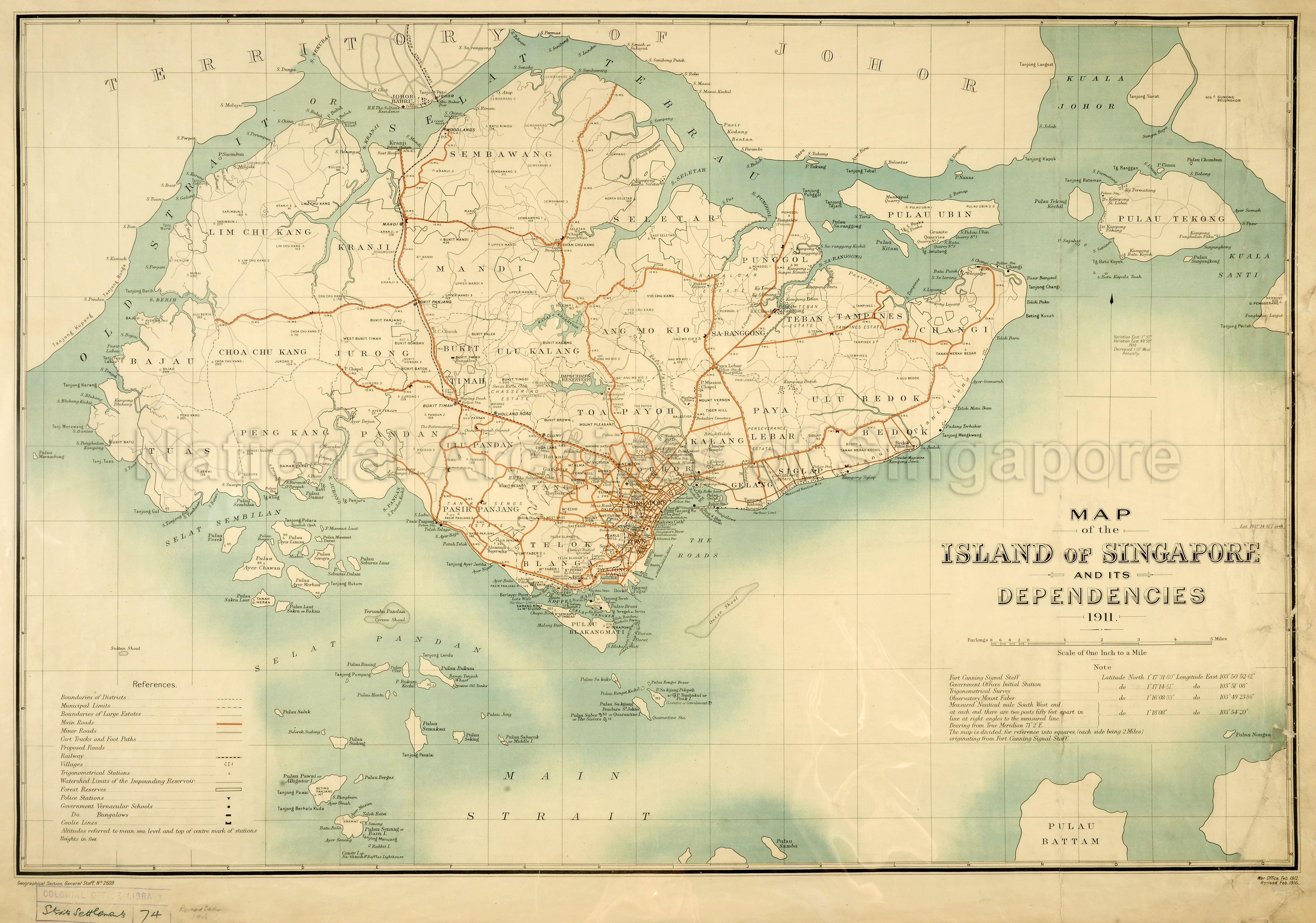
Map of the Island of Singapore and its Dependencies 1911
1916
This map of Singapore Island and its dependencies shows boundaries of districts (or mukims) like Ang Mo Kio and Toa Payoh, municipal limits, boundaries of large estates, Trafalgar Estate and Tan Kim Seng's, main roads, mile stones (M S), minor roads, cart tracks and foot paths, railway from Pasir Panjang to Woodlands via Tank Road and Bukit Timah Road, villages or kampongs, trigonometrical stations, heights in feet, watershed limits of Impounding (MacRitchie) Reservoir, forest reserves, police stations, government vernacular schools, government bungalows, coolie lines, clubs, place names, barracks, cemeteries, Old Strait or Selat Tebrau (Selat Johor), Johor Bahru, islands, Pulau Ubin, Pulau Tekong, Pulau Blakang Mati Pulau Brani, Pulau Bukum (Bukom), Pulau Ayer Chawan, Pulau Ayer Limau (Merlimau) and Pulau Ayer Merbau, rivers, Sungei Kranji, Sungei Seletar, Sungei Ponggol, Sungei Saranggong, Sungei Jurong, Singapore River and Kalang River, St Michael's Rifle Range, race course, library and museum, Raffles Hotel, Raffles Institution, St Andrew's Cathedral, Hotel del Europe, Government House, government offices, Commercial Square, Keppel Harbour, wharves, docks, criminal prison, lunatic asylum, General Hospital, Fort Canning, Mount Sophia, Pearls Hill, Chan Chu Kang (at the eastern end of Mandai Road), and others.
2016HDD0001 - 0153_CO1047_888
CO 1047/888
Similar map in D2016_000261 and D2018_000215_RGS
Published in War Office
Geographical Section, General Staff (G.S.G.S.) No.2609
C.O. Library Straits Settlements 74
Geographical Section, General Staff (G.S.G.S.) No.2609
C.O. Library Straits Settlements 74
Viewing permitted. Commercial use and reproduction require written permission from copyright owner or source.
Copies and reproductions can only be made for the purpose of educational/academic research, private study and scholarship with proper citation of The National Archives (TNA) as the original source. Any other uses or commercial uses such as illustrative use in publications such as books, magazines or online, or in exhibition displays require permission from The National Archives and this will involve a display fee and correct citation. To use the map in this context, please contact The National Archives image library at : image-library@nationalarchives.gov.uk
Processing of requests may require 3-5 working days
